Proprietary data.Hourly refresh.Better forecasts.

WindBorne’s model portfolio includes WeatherMesh-6 Global and WM-6 3km, our next-generation AI models, and MetaMesh, our blended point-forecast model.

Our models

AI and blended. One forecast stack.

WeatherMesh is our record-breaking AI model. MetaMesh blends WeatherMesh with public AI and NWP models.

AI model

WeatherMesh‑6 Global

Resolution
~25 km (0.25°)
Coverage
Global
Forecast horizon
360 hours (15 days)
Forecast time step
3-hour
Update frequency
Hourly
Output type
128-member ensemble
Variables
163 total: 125 upper-air + 38 surface variables
Backtest availability
April 2025 to present

Technical details

Proprietary observations and continuous AI data assimilation

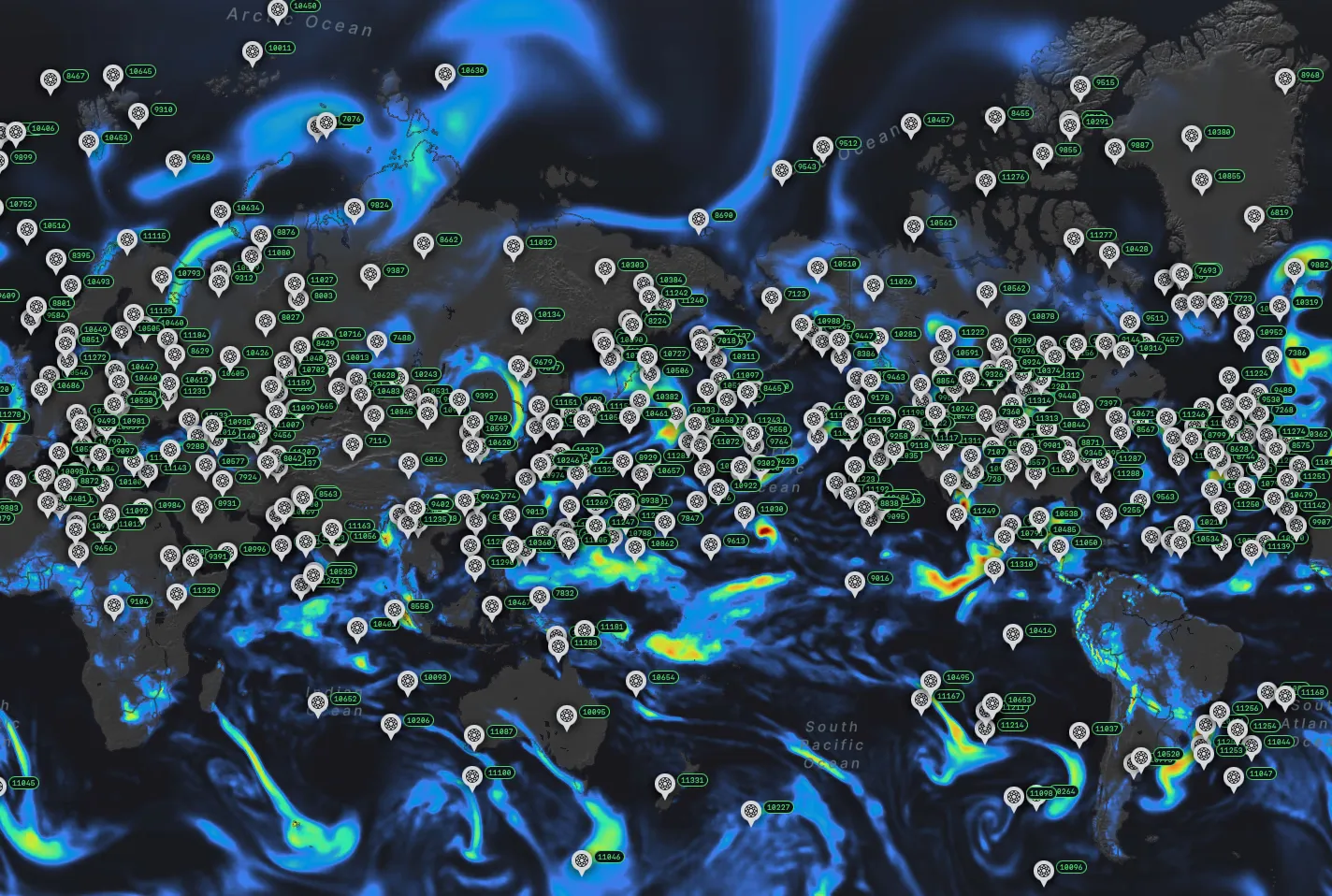
WindBorne pairs a global proprietary observation network with an independent AI data assimilation system, giving every model a more complete view of the atmosphere.

Global precipitation forecast with WindBorne balloon observations overlaid
  • Transformer-based AI model

    State-of-the-art neural network architecture optimized for processing weather data

  • Modular architecture

    Encoder-processor-decoder structure enables flexible training and efficient inference

  • Latent space representation

    Weather states are mapped into a latent space for efficient pattern recognition

  • Comprehensive dataset

    Trained on more than 50 years of historical weather data, augmented by observations from our proprietary network

Verified performance

Benchmarked against operational NWP models. State-of-the-art accuracy.

Built for real-world decisions

Earlier signals, more frequent updates, and transparent performance help teams respond as the forecast changes.

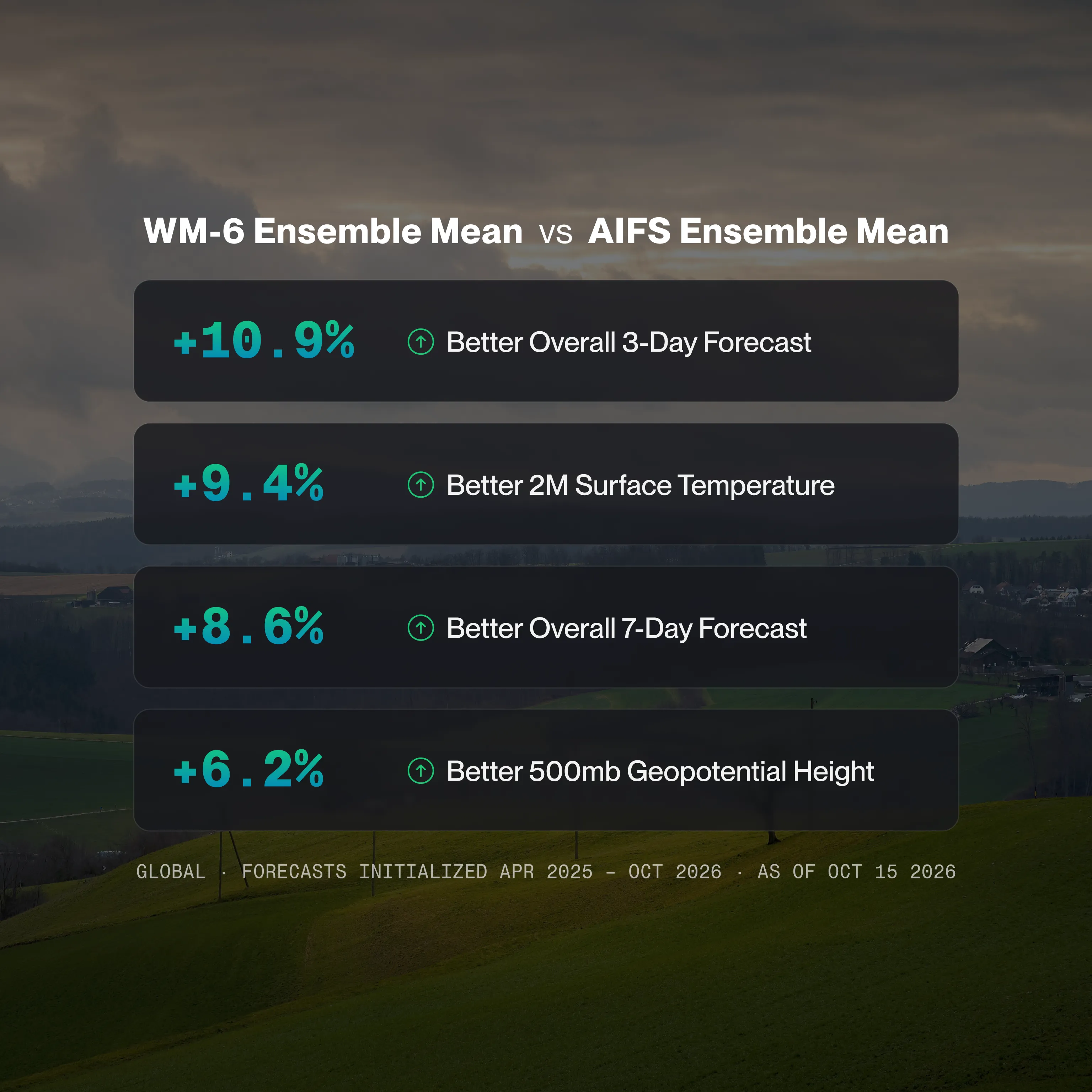
WM-6 versus AIFS ensemble mean benchmarks: 10.9% better overall 3-day forecasts, 9.4% better 2-meter surface temperature, 8.6% better overall 7-day forecasts, and 6.2% better 500mb geopotential height. Global forecasts initialized April 2025–October 2026, as of October 15, 2026.

WM-6 vs. AIFS ensemble mean

  • 10.9% better overall 3-day forecast
  • 9.4% better 2-meter surface temperature
  • 8.6% better overall 7-day forecast
  • 6.2% better 500mb geopotential height

Global forecasts initialized April 2025–October 2026. Snapshot as of October 15, 2026.

Explore the benchmarks

Forecast accuracy and impact

Industry-Leading Accuracy at 15 Days

Proprietary observations, AI-native data assimilation, and high-frequency model cycles are designed to deliver best-in-class forecast accuracy across the full 15-day horizon.

See the benchmarks
Earlier Signal on Extreme Events

Extreme events create the greatest operational risk. WindBorne models are designed to surface them earlier. For example, our model flagged Storm Kristin three days before ECMWF and GFS converged.

See case studies
Hourly and Sub-Hourly Updates

WeatherMesh-6 forecasts update every 15 minutes (WM-6 3km) and hourly (WM-6 Global), replacing discrete six-hour cycles with a continuous forecast signal. This gives teams a continuously updated view as conditions and model confidence evolve.

Delivery

API + Insights platform. Built for production.

Every forecast product is delivered via REST API and an interactive insights platform. Your automated systems get programmatic access, and your team gets a meteorological-grade interface that shows why a model is producing a given forecast.

  • RESTful JSON API
  • Insights platform
  • Sub-second latency
  • Python SDK
  • Custom variable queries
  • One year of backtest data
View API documentation
forecast.py
Python SDK
from windborne import get_point_forecasts

# By coordinates
point_forecasts = get_point_forecasts(
    coordinates="37.77,-122.42")

# By station
point_forecasts = get_point_forecasts(
    stations="panc;kjfk")

Learn more

Go deeper on the models

Common Questions

What backtest data is available?

Backtests for both WeatherMesh-6 models are available from April 2025 to present, so you can score on your own variables and regions before going live. Our blended model MetaMesh dynamically recalibrates its weights as new input models arrive, so historical backtests would not accurately represent live model performance. For this reason, MetaMesh is available as a live forecast product only.

How is MetaMesh different from WeatherMesh models?

WeatherMesh-6 is our AI forecast model, trained on proprietary observations and running hourly. MetaMesh is our blended point forecast product: it combines HRRR, GFS, GFS Ensemble, IFS, IFS Ensemble, AIFS, AIFS Ensemble, and WeatherMesh models with dynamically learned weights that adapt by variable, lead time, region, and season. WeatherMesh is the raw AI signal. MetaMesh is the best-of-breed consensus. It updates on a rolling basis with hourly time steps out to 15 days, optimized for over 5,349 METAR stations with dynamic global coverage.

How do I integrate with my existing systems?

REST API with JSON and Zarr responses for point and gridded data, plus a Python SDK. Most teams can begin pulling data within a day of onboarding. View API documentation.