Read the article
here.The most skillful global weather model
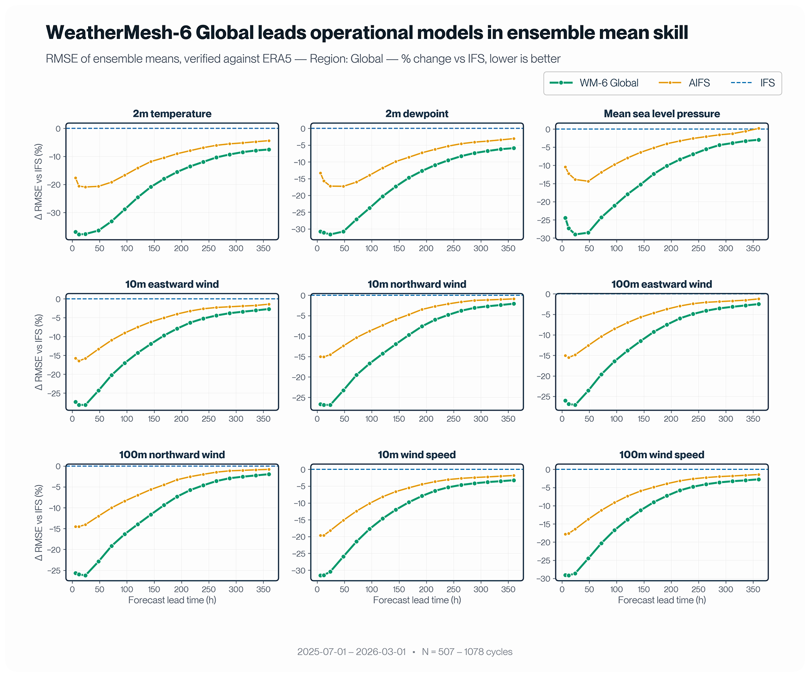
WeatherMesh-6 (WM-6) Global is the most skillful medium-range forecasting model to date, whether NWP or AI. Operating at 0.25-degree (roughly 25km) resolution, it produces more accurate forecasts than the leading operational models—ECMWF's IFS and AIFS ensembles—across every weather parameter and lead time we evaluated. Over the evaluation window of July 2025 through March 2026, WM-6 achieves up to 38% lower ensemble-mean RMSE than IFS and up to 32% lower than AIFS. Most strikingly, for 2-meter temperature, WM-6's 4.5-day forecast is as accurate as a 1-day forecast from IFS. Operational forecast skill has historically advanced by roughly a day of lead time per decade; by that measure, WM-6 delivers in a single model what would have taken three decades.
Due to data access limitations, we were unable to directly compare WeatherMesh-6 with Google DeepMind's FGN, another AI weather model at the skill frontier. In indirect comparisons, WM-6 Global appears competitive with—if not slightly more skillful than—FGN across all variables we examined.
A more complete picture of the atmosphere
With 24 new surface, soil, and atmospheric parameters, in addition to 5 upper-air parameters at 25 pressure levels, WeatherMesh-6’s output catalog is the largest of any AI weather model to date. New soil temperature and moisture fields, along with skin temperature, give the model direct access to land-atmosphere coupling, fundamentally improving its ability to learn surface physics. A full suite of radiation variables enables downstream solar energy applications, while additions like cloud cover decomposed into high, medium, and low layers, and boundary layer height broaden WM-6's utility across sectors, from aviation to energy to agriculture. For a complete list of available parameters, see our API documentation.
A more calibrated ensemble, in latent space
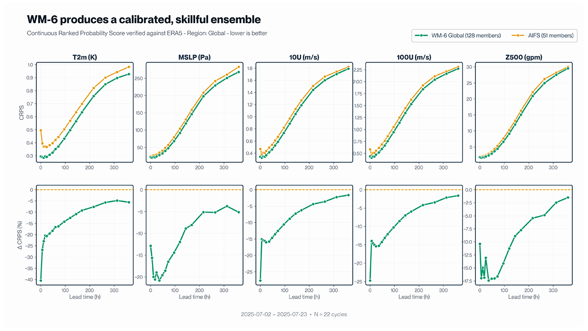
WeatherMesh-6 models a full ensemble in latent space—an approach we will detail in an upcoming technical report. This is reflected by a competitive CRPS (Continuous Ranked Probability Score), which captures both forecast skill and ensemble calibration. In our preliminary evaluation for the month of July 2025, WM-6's 128-member ensemble outperforms AIFS's 51-member ensemble on CRPS across key surface and atmospheric variables, and at every lead time from the initial hours out to 15 days.
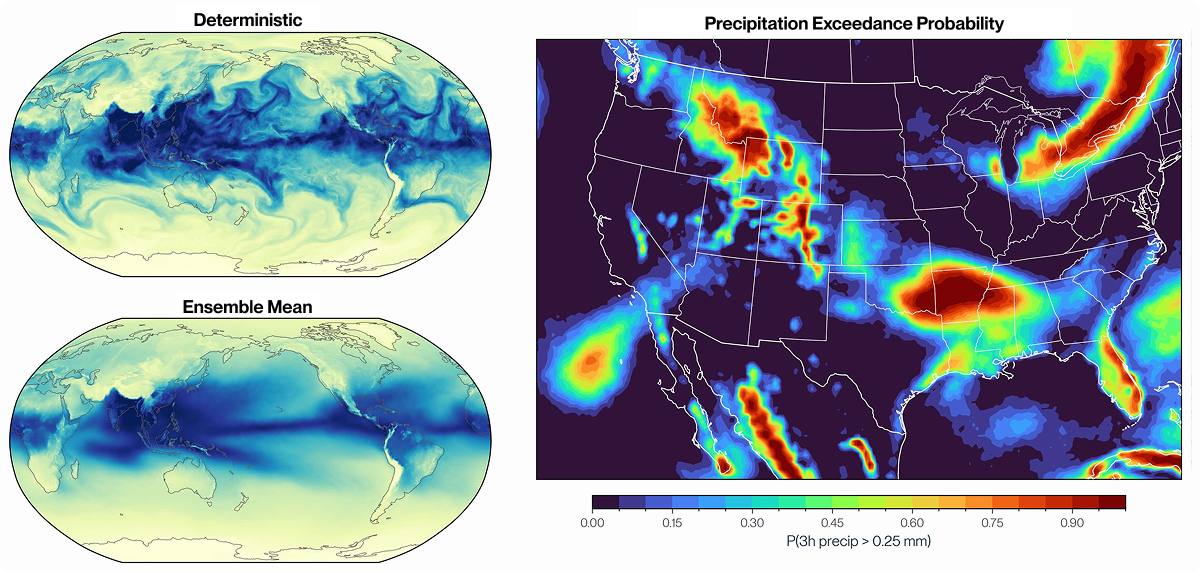
This approach also lets us produce realistic ensemble members. Each member is at full resolution and physically coherent across weather parameters, which enables sophisticated use cases such as scenario analysis and extreme-event detection, as well as parameter-coupled use cases like wind-energy forecasting. Alongside individual members for key parameters, we also distribute processed statistics, including percentiles and precipitation exceedance probabilities, so users can still understand the distribution of uncertainty if they do not wish to ingest the whole ensemble.
Improved data assimilation
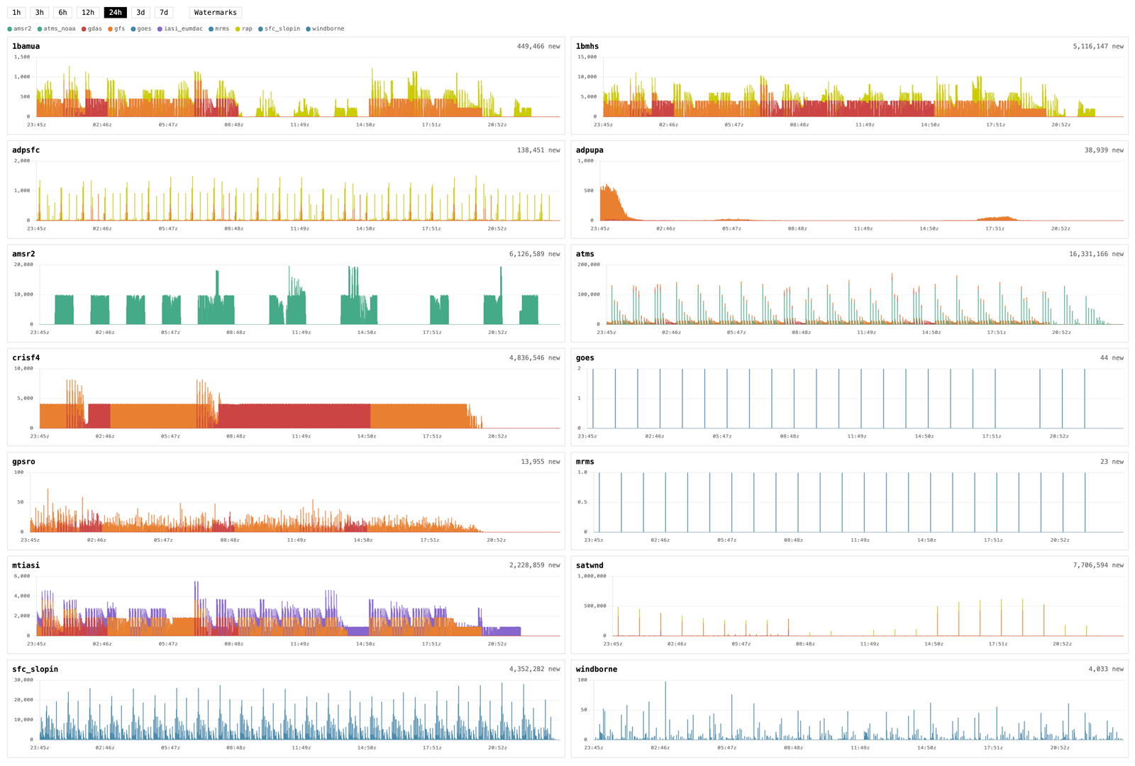
With WeatherMesh-6, WindBorne’s AI DA architecture has been redesigned around ensemble methods: Instead of producing a single corrected atmospheric state, WM-6 generates multiple ensemble members at analysis time, yielding calibrated uncertainty estimates from the start. WeatherMesh-6 also adds two new satellite instruments to its data assimilation system: AMSR2, a microwave imager that provides ocean surface and precipitation information, and CrIS, a hyperspectral infrared sounder that complements IASI with additional vertical temperature and moisture profiles—bringing the total to 11 distinct observation types ingested. Furthermore, WindBorne's own Global Sounding Balloon observations are now encoded using an innovation-based approach: the model directly sees the difference between what the balloon measured and what the background forecast predicted at that location, allowing it to more efficiently learn from the limited, but rapidly growing, history of this observation type.
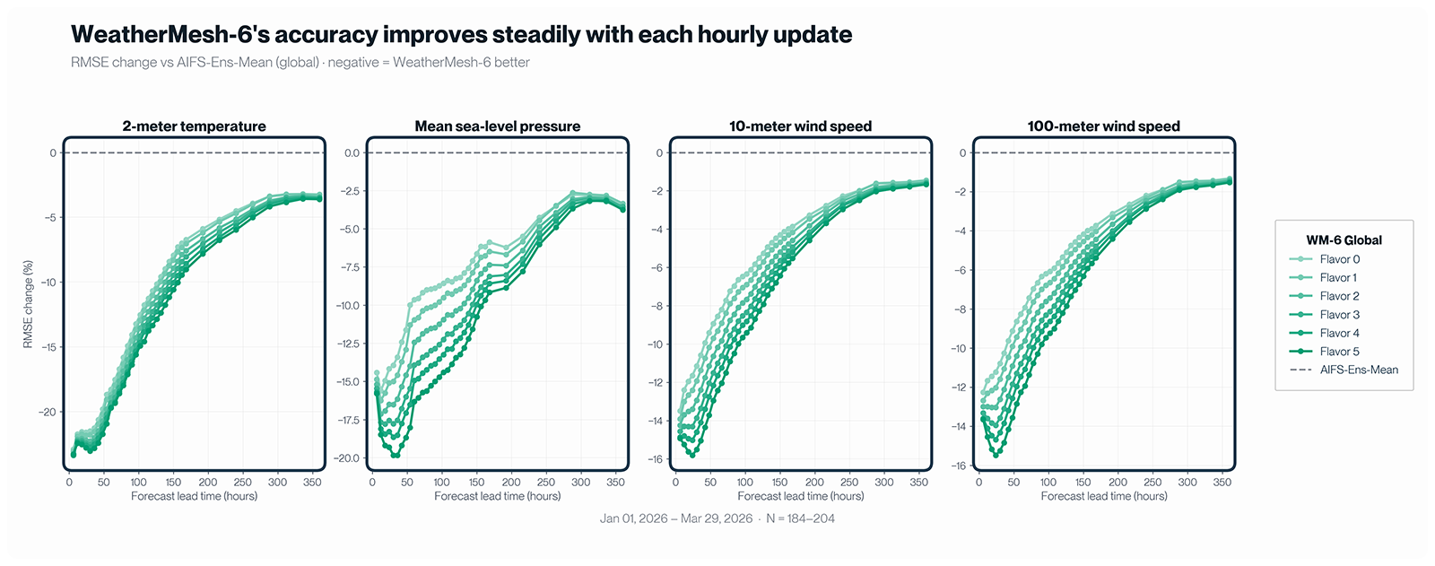
With AI DA, WM-6 Global produces a fresh forecast every hour, and accuracy improves steadily with each run. A bit of terminology first: Each forecast cycle is anchored to a synoptic time, 0z, 6z, 12z, or 18z. At 0z, a WM-6 Global run begins, assimilating all observations available up to 0z; its forecasts are ready within 30–40 minutes. We call this the “Flavor 0" run of the 0z cycle. At 1z, a new run starts with another hour of observations folded in—"Flavor 1"—and so on. Major operational models, such as IFS and AIFS, typically become available between 5z and 6z, so Flavor 4 (the 4z run) is the last WM-6 Global update to land comfortably ahead of them. Flavor 5, the final run of the cycle, starts at 5z; at 6z, the count resets to Flavor 0 of the 6z cycle.
So how much does each update help? With WM-6's substantial skill advantage, even the Flavor 0 run already outperforms the AIFS ensemble—and the gap grows larger as later flavors assimilate more recent observations. For 100-meter wind speed 3 days ahead, for instance, WM-6 ranges from 7.4% more accurate than AIFS at Flavor 0 (~5 hours before AIFS is available) to 11.4% more accurate at Flavor 5 (around the same time as when AIFS arrives).
Higher-resolution forecasting with WM-6 3km
The WeatherMesh-6 family includes a 3km-resolution model that resolves significantly finer detail. WeatherMesh-6 3km assimilates additional high-resolution observations, such as GOES geostationary satellite imagery and MRMS multi-radar composites, unlocking access to convective-scale features. A terrain-aware upscaling path injects fine-grained elevation and soil data, enabling the model to resolve orographic effects that shape local weather. Trained on high-resolution analyses over CONUS and Europe, the model also generalizes to regions outside these training domains. By jointly optimizing against diverse targets and direct observations—radar, satellite, surface stations, and high-resolution regional analyses alongside the global ERA5 reanalysis—the model learns a richer, higher-resolution internal representation of the atmosphere than the traditional ERA5-based training can provide.
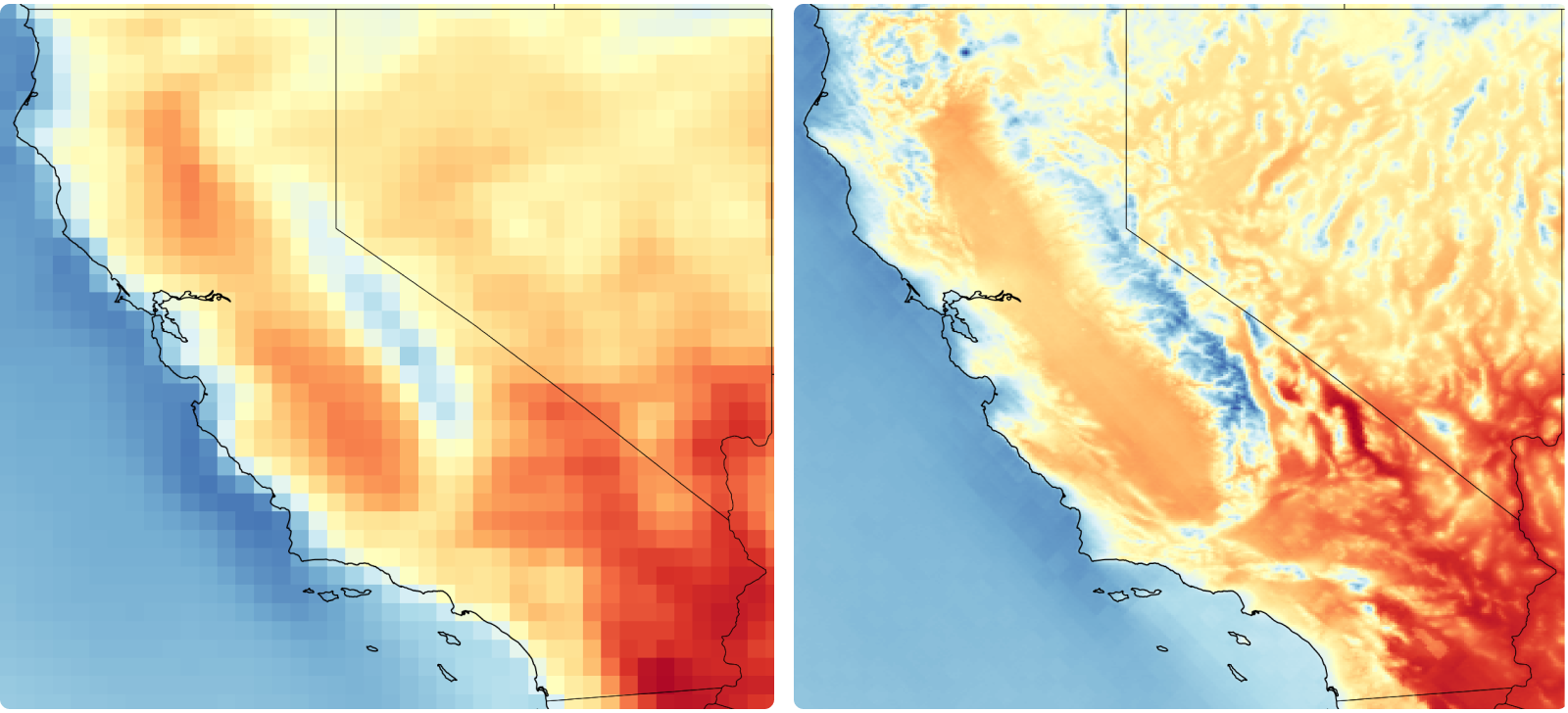
Over CONUS, WeatherMesh-6 3km achieves the highest accuracy of any model we tested against ground observations (METARs) for key surface parameters like temperature and wind speed—outperforming NOAA's HRRR at every forecast hour beyond hour 0. It also extends the forecast horizon to 72 hours, a full day past HRRR's 48, and refreshes every 15 minutes.


