Read the article
here.A look back at how highly targeted WindBorne balloon missions gathered critical weather data before and during a spring 2024 continental U.S. tornadic storm

Late last month, a severe tornadic thunderstorm formed in the Lincoln-Omaha area of Nebraska and swept across Iowa and the Great Plains. A string of dozens of tornadoes damaged towns and homes, injured civilians, and caused dangerous power outages and gas leaks.
Traditional weather balloon systems aren’t well-positioned to gather critical early storm data in the wake of developing weather: they must be launched by a human operator at the location of observation. If they are launched, their data capturing ability is limited: they can only capture a single vertical data slice per flight, directly vertically from their point of launch.
If the launch locations of these traditional balloons doesn’t happen to be optimal for a specific weather development, the observations may not be valuable. And if the traditional balloons do happen to be positioned well to gather data, the effort to launch the balloons could pose a risk to the operator’s life.

WindBorne’s nimble, remotely controlled pre-storm data sampling
By contrast, WindBorne is able to launch balloons from our network of global launch sites, which span three continents: the US, Asia, and Africa, quickly navigating to target regions anywhere in the world. This means that at a significantly lower cost and significantly greater profiling capabilities – without risk to human operators – we can carefully direct our balloons into specific atmospheric areas of interest.
Our smart balloons intelligently ascend or descend to vertical layers where winds propel them to regions of expected severe weather. (See more on our balloon platform and flight autonomy software in our Blog post introducing our three-part tech stack). This enables our balloons to fly through the troposphere to observe conditions – particularly atmospheric instability and wind shear – which are necessary for understanding and predicting storm initiation, development, and forecasts.
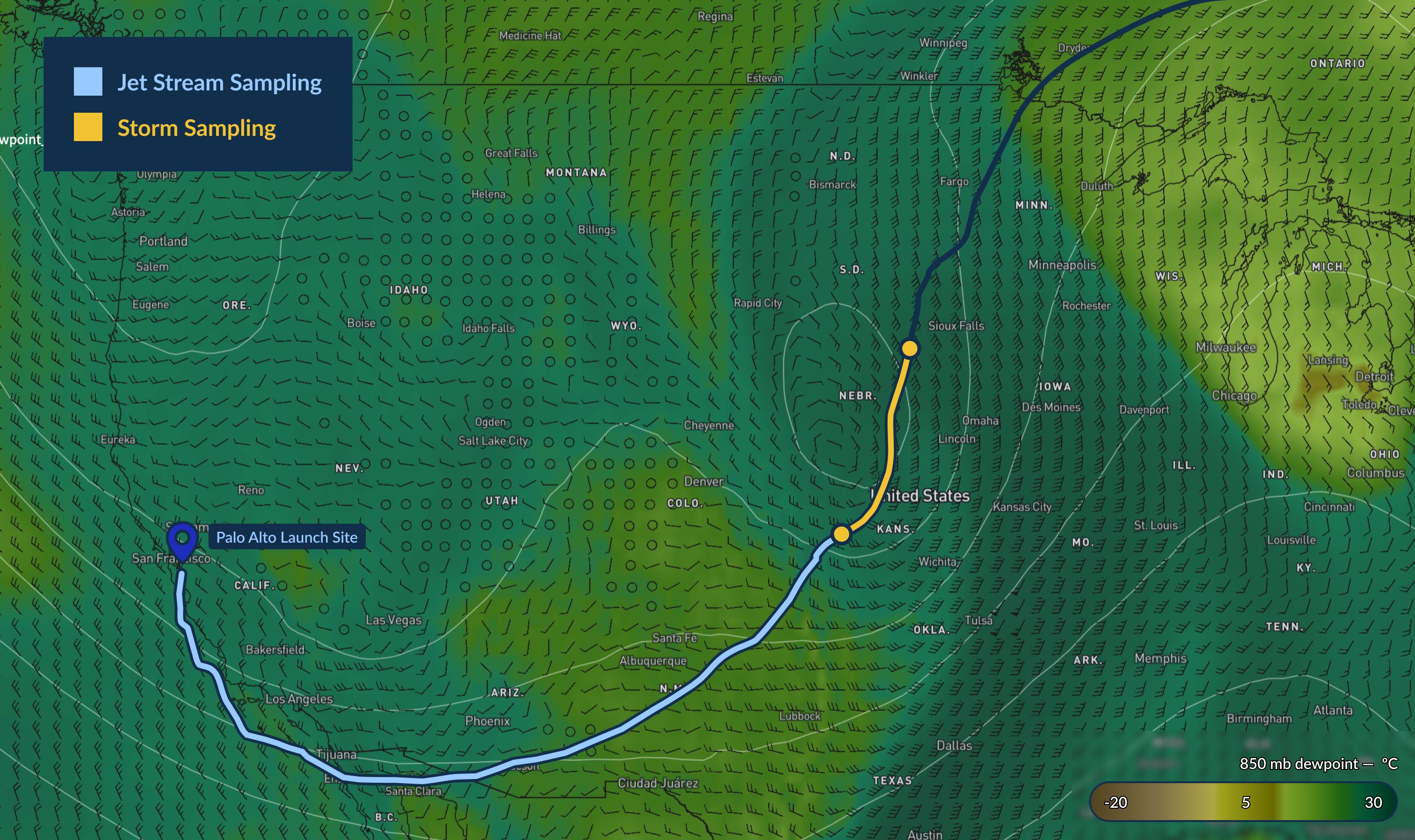
When early indicators of the tornadic thunderstorms developed, we flew a number of balloons from our Palo Alto, Calif. headquarters to critical pre-storm areas from Oklahoma to South Dakota ahead of the storm.
Our smart balloons intelligently ascend or descend to vertical layers where winds propel them to regions of expected severe weather. (See more on our balloon platform and flight autonomy software in our Blog post introducing our three-part tech stack). This enables our balloons to fly through the troposphere to observe conditions – particularly atmospheric instability and wind shear – which are necessary for understanding and predicting storm initiation, development, and forecasts.
When early indicators of the tornadic thunderstorms developed, we flew a number of balloons from our Palo Alto, Calif. headquarters to critical pre-storm areas from Oklahoma to South Dakota ahead of the storm.

As an example, our flight W-1276 departed our Palo Alto headquarters around 8pm PT on April 24, riding a jet stream for 16 hours across Southern California, Arizona, and New Mexico, allowing our system to sample the jet stream in the upper levels of the troposphere on Thursday while flying toward the storm environment.
W-1276 was successfully able to capture defining characteristics for understanding storm initiation, including data in a location where a tornado formed less than four hours later. In one profile example collected within the pre-storm environment, you can see what’s known as a “loaded gun sounding,” signature of a condition in which warm moist air is trapped below hot, dry air – an unstable environment that’s key to enabling thunderstorm development.


Other WindBorne balloons also collected a range of vertical samples between Oklahoma and South Dakota, observations that were only achievable due to our balloons’ ability to intelligently shift altitude throughout flight, a capability not held by traditional weather balloons.
The power of atmospheric data to improve forecasts
Atmospheric data profiles are powerful not only for understanding the current state of the atmosphere and real-time conditions, but as importantly, for forecasting extreme weather.
Recent studies by NOAA and EMC have shown the addition of even limited WindBorne atmospheric data to improve ground track prediction accuracy for tropical cyclones by as much as 18%, a significant and highly efficient improvement. (Our balloon sensing scale today is already about double the scale at the time of this study.)
Results like this underscore the significant value to both the public and private sector of gathering and incorporating more comprehensive, high-quality observations into our forecasts.
Forecast improvements don’t, however, stop at better data. Through new approaches to deep learning infrastructure and modeling, we’ve made further improvements to global forecasting modeling with our AI-based forecast model, WeatherMesh, which you can learn more about here.
Follow our Blog and social handles (check out LinkedIn, Twitter, and Instagram) to follow timely WindBorne weather observations and insights.


