Read the article
here.Get introduced to the three core layers of our tech stack: the balloon platform, flight autonomy software, and AI-based weather forecasting
- Layer 1: The Balloon Platform
- Layer 2: Flight Autonomy Software
- Layer 3: AI-Based Weather Forecasting
WindBorne is on a mission to mitigate the most immediately destructive aspects of climate change: extreme weather and weather uncertainty. To start, we’ve set out to improve global forecast accuracy multi-fold.
One of the reasons weather forecasting is such a complex puzzle is because it requires innovation across both weather data collection (commonly referred to as “observations”), as well as innovation in forecast modeling technology itself.
When we founded WindBorne in 2019, we were focused wholly on the first piece of this puzzle: improving environmental & weather data collection. The most significant real-time data gap, according to the World Meteorological Organization (WMO), is the atmosphere – 85% of which is effectively unobserved. This gap led us to invent, build, and operate a now-global constellation of one-of-a-kind autonomous, sustainable, long-duration weather balloons.
While we continue to scale this global constellation and experiment with exciting observation R&D, we’ve since become a full-stack weather intelligence company: owning data collection, proprietary AI-based forecast modeling, and forecast productization. This vertical integration enables each part of the stack to be better optimized: the model can be tuned to take optimal advantage of the data, and vice versa, supporting higher quality data collection and forecasting accuracy than if the efforts were detached.
Here is a snapshot of each layer of our weather intelligence stack to help you get acquainted with the breadth of technology at WindBorne.
Layer 1: The Balloon Platform
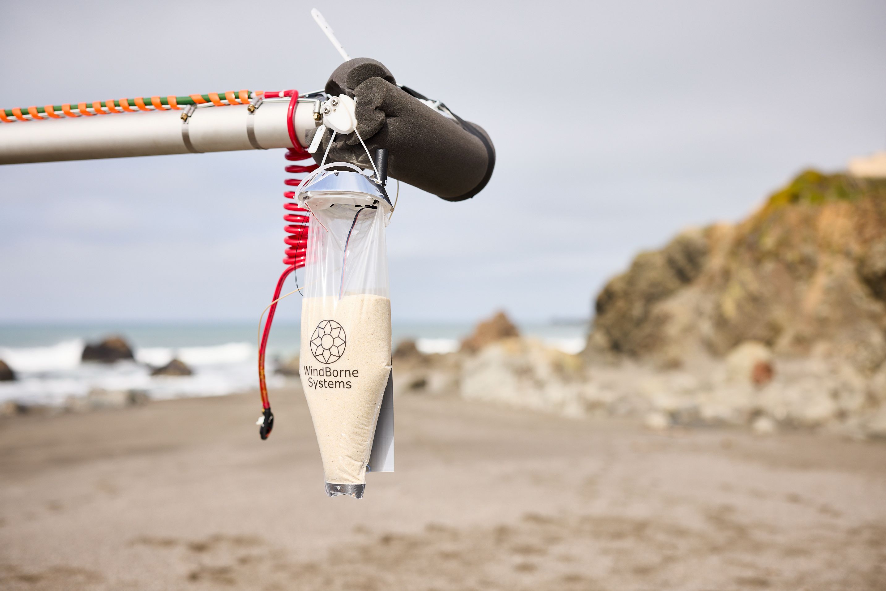
Since 2019, we’ve launched more than 1,000 autonomous, long-duration atmospheric sensing balloons to gather data for the 85% of the atmosphere that remains unobserved. We now operate the largest, most cost-effective, and most sustainable in-situ atmospheric sensing system on the planet.
Each balloon weighs just 1.2 kg, or 2.6 lbs, most of which is composed of sand ballast. Our balloons are equipped with proprietary sensors and a customized avionics package that enables real-time communication and navigation (more on that next).
WindBorne balloons gather 10x more data per dollar over land and 150x more data per dollar over oceans compared to the alternatives: traditional, single-use weather balloons called radiosondes, which only fly for a few hours and gather a single data slice over land, and dropsondes, small sensing devices manually released from manned aircraft over oceans.
By comparison, WindBorne’s balloons use a fraction of the materials of traditional balloons and can fly for 40+ days, uniquely taking dozens of profiles throughout programmed flight paths that can readily travel over oceans, deserts, and the Earth’s most remote places.
The atmospheric data gathered in these profiles is purchased by partners and customers such as governments; the data also improves our AI-based forecast models (more on this later.)

Layer 2: Flight Autonomy Software

We design, build, and operate the only sensing balloons that can autonomously navigate and target specific atmospheric data anywhere in the world.
The second key layer of our tech stack is our proprietary flight autonomy software, which enables each of our balloons to intelligently shift altitude to navigate to different wind layers and capture specific vertical data slices (also known as “atmospheric profiles”).
Ground-based software analyzes weather patterns and sends flight plans to each balloon’s “brain.” Each balloon then operates autonomously to execute that flight plan and collect data. Together, these systems are capable of steering balloons out of specific regions, navigating GPS interference, avoiding populations while safely sampling low altitudes, and optimizing global flight paths to maximize data per cost dollar.
Our flight autonomy software navigates based on our own deep learning-based weather forecast model, WeatherMesh (which we’ll cover next).
While our balloons are largely autonomous, we still monitor our network 24-7 via our Mission Control Center and can manually intervene at any time.
As we continue to scale our constellation, we’ll be shifting our autonomy software to operate on a constellation-level vs an individual balloon-level.

Layer 3: AI-Based Weather Forecasts, aka “WeatherMesh”

The newest layer of our weather intelligence stack is record-breaking AI-based weather forecasts via our in-house model, WeatherMesh, which we announced in February 2024. WeatherMesh has unseated Google DeepMind’s GraphCast as the most accurate medium-range global forecast model in the world. The model also surpassed the gold-standard for traditional physics-based weather modeling, known as numerical weather prediction (NWP), held by the European Centre for Medium-Range Weather Forecast (ECMWF)’s medium-range model (ENS). (You can check out our publicly available, real-time forecasting benchmarks here.)
Retrospective case studies on major events like Hurricane Ian and the 2022 global tropical storm season have helped illuminate the immense potential for models like WeatherMesh to improve public safety and readiness for extreme weather events. Forecast improvements also have great potential to help private businesses better manage weather, resources, and mitigate damages.
WeatherMesh, which predicts temperature, pressure, wind speed and direction, dew point, cloud cover, incoming radiation, and precipitation, represents the equivalent of years-worth of forecasting advancement. We achieved these accuracy and operational feats while being substantially more efficient than both other AI-based and traditional NWP models. While NWP models rely on supercomputers using hundreds of times more compute, WeatherMesh can run on a gaming laptop.
WeatherMesh is powered by an innovative machine learning architecture and new deep learning modeling techniques, which allow it to train on vast amounts of both historical and real-time data. This includes both live input operational data, as well as extensive historical data sets, such as the ERA-5, the ECMWF’s estimate of hourly weather variables for the past eight decades.
WeatherMesh generates forecasts with one-hourly resolution, making them ideal for real-time applications. Other top AI models, by contrast, produce forecasts with six-hourly resolution. WeatherMesh also benefits from our unique atmospheric data, which includes real-time measurements of temperature, wind speed and direction, pressure, and humidity, captured through our balloon constellation.
WeatherMesh now powers our entire autonomous balloon network, making WindBorne the first company to control real-world assets with AI forecasts at scale and replacing our use of Numerical Weather Prediction (NWP) forecasts for balloon navigation.
We are now making our AI-based forecasts available to commercial partners.


