Landing a WindBorne Balloon in the Eye of Typhoon Dolphin
For many years, the WindBorne team has dreamed of getting one of our vertically controllable Global Sounding Balloons (WindBorne's long-duration weather balloon, which changes altitude to steer and collects soundings around the world.) into the eye of a A rotating storm that forms over warm tropical oceans, called a hurricane, typhoon, or cyclone depending on where it occurs.. It is no small feat. Challenges involve (1) identifying nearby balloons with the best chance of interception, (2) navigating said balloons towards the storm from above, (3) finding the right location and moment to send each balloon down to descend into the eye of the storm.
This past weekend, our team finally achieved this goal! After a string of failed attempts and hard-won lessons, we navigated a balloon into the storm, sent it down into the eye (where it may have gotten as low as only 8 meters above sea level), then launched it back up by over a kilometer and collected multiple vertical profiles while circling the eye.
To our knowledge, this is the first time such a balloon maneuver was done in a tropical cyclone.
Once we identified our candidate balloon W-9642 (launched from our Hawaii site) our first hurdle was to navigate it towards the storm. Since our team has the ability to control the altitude of our balloons (by opening a vent to descend and releasing Extra weight a balloon carries and can release to climb higher or stay aloft longer. to ascend), we decided to use different wind speeds and directions in the upper atmosphere to our advantage. To approach the storm, we kept the balloon above 20km altitude where fast winds from the east could help us catch up to the storm. If we needed to slow down, or adjust direction, we lowered the balloon by a few kilometers where the wind speeds were slower and could help shift the balloon south or east.
One of the biggest challenges with this approach is evading deep thunderstorms. Especially when farther out from the center of a hurricane, where intense thunderstorms can form with little notice, their clouds create heavy rain and turbulent motion extending well up in the atmosphere (well over 14 kilometers). These conditions threaten our ability to maintain altitude. We kept a close watch on weather conditions surrounding W-9642 and adjusted course as needed, while making sure that each adjustment did not place us too far off target.
As we approached the storm the question became one of timing: exactly when to begin the descent and what speed was needed to descend into the center of the eye. For such high stakes calculations, traditional global weather models do not give us enough resolution to achieve the desired precision. We estimated the balloon’s trajectory using National Oceanic and Atmospheric Administration, the U.S. federal agency responsible for weather forecasting, ocean monitoring, and climate science.’s state-of-the-art Hurricane Analysis and Forecast System (HAFS-A) model, which features a high-resolution mesh with about 3 km horizontal resolution following the storm. After accounting for how accurately the model resolved the storm’s structure and intensity compared against satellite observations, we calculated a flight plan that would achieve a soft landing in the eye.
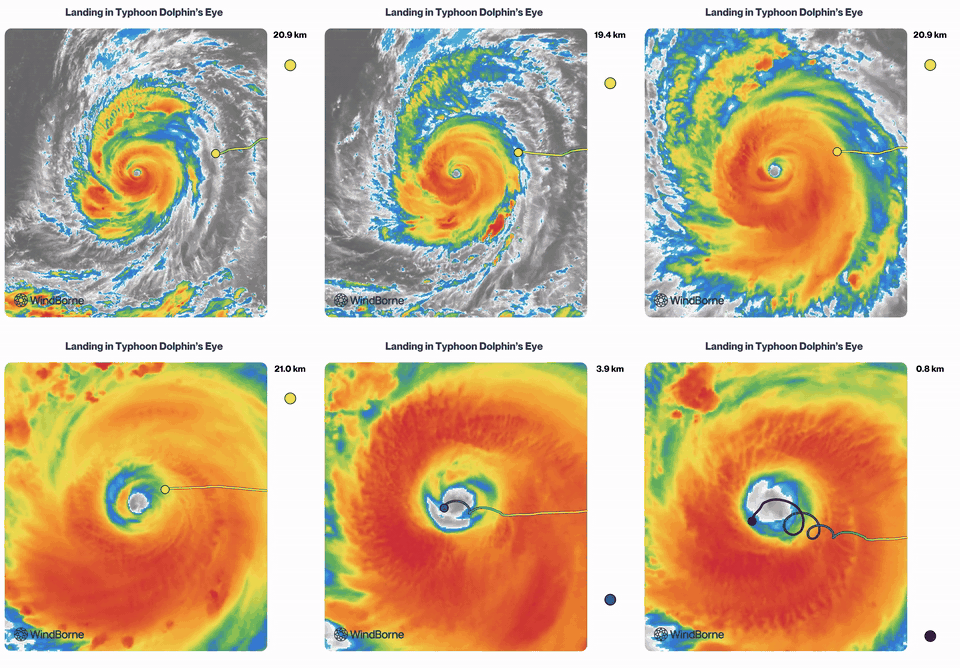
…and we made it
W-9642 gave us a first-of-its-kind dataset. Not only did we land in the eye of Typhoon Dolphin, but we also completed three full loops inside its eye before the balloon drifted into the eyewall. At the lowest point of those loops (about 8 meters above sea level), the balloon measured a pressure of 929 mb. That is a direct measurement of the storm's intensity, not an estimate. It recorded a 155 mph sustained wind at just under a kilometer above sea level in the eyewall before it stopped transmitting.
We are still working through analyzing the data we collected in the storm, and we plan to make it available for research purposes. This was a massive feat accomplished through careful and calculated navigation and collaboration across multiple teams at WindBorne. We are excited about the value of this data and where we can take this in the future.