.gif)
Read the article
here.Tomer is a senior meteorological scientist at WindBorne, working on evaluating weather model forecasts for weather phenomena such as cold outbreaks, heat waves and tropical cyclones, and finding new ways to integrate forecast uncertainty into balloon operations. Outside of work and being a weather enthusiast, Tomer enjoys running, hiking, traveling, and computer programming.
Last week, I had the opportunity to spend some time with the Center for Western Weather and Water Extremes (CW3E) in sunny and warm La Jolla, California… except it wasn’t sunny or warm during my stay. We were impacted by a series of Atmospheric Rivers (ARs), which are long corridors of moisture that bring heavy precipitation to the West Coast. It was a well-timed turn of events as I was in town to collaborate with CW3E on the AR Recon program.
What is AR Recon?
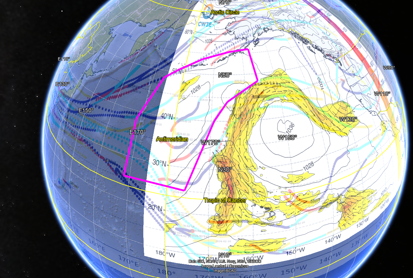
You may be wondering what AR Recon is… first I’ll start by explaining the importance of atmospheric rivers. They are a major driver of wintertime precipitation in the West Coast, and AR Recon allows us to better predict where and when an AR will make landfall along the coast and how much rain and snow it will produce. This is no easy task, as it is a challenge to capture data over the data-sparse Pacific Ocean; unlike land, where weather stations, radar, and ground-based instruments provide constant measurements, the open ocean has very few observation points, making it one of the biggest gaps in global weather data.
To that end, AR Recon has daily calls to analyze the current weather and the forecast, find regions where collecting weather observations can have a significant impact on improving the forecast as well as recording valuable data for research, and send out aircraft to those regions if they are within the plane’s flight range. These are the same planes used during the summer by the hurricane hunters – NOAA’s Gulfstream IV (G-IV) and the US Air Force’s WC-130J.
A typical day in an AR Recon field campaign might go like this: imagine you are in charge of analyzing the forecast, and the latest forecast models have significant differences in where an AR might impact the West Coast in a few days. The precursor weather disturbance is near Hawaii, where a G-IV aircraft is stationed, and analysis of the latest data shows collecting observations within and west of the moisture plume can have a significant impact on where rain falls in California in a few days. The group collaborates on planning a flight route that collects data from these areas, and the plane then flies through that route, collecting flight-level measurements plus dropsondes (instruments dropped from the aircraft that measure temperature, humidity, wind, and pressure as they fall through the atmosphere). The data is then sent to national modeling agencies to be ingested into NOAA’s GFS model and the ECMWF’s IFS model, the global weather models that ultimately power the weather forecasts available on your phone and your local news station.
So where does WindBorne Systems come into the equation?
These aircraft are able to fly in conditions that are unsafe for WindBorne’s balloons to operate in – after all, these are the same planes that penetrate the core of vicious Category 5 hurricanes – but they are limited in how far and where they can fly. With WindBorne’s growing constellation of balloons spread out across the Northern Hemisphere, chances are that at least some of our balloons are located in areas of importance for the forecast over the Pacific Ocean but which are out of reach for the aircraft. Unlike traditional weather balloons, which ascend once, collect a single snapshot of the atmosphere, and pop, WindBorne's balloons are designed to fly for weeks at a time, drifting across oceans and collecting continuous measurements (which is what makes them so valuable in data-sparse regions like the Pacific). When those opportunities arose, we collaborated with the AR Recon team on identifying where our balloons should collect vertical profiles, which are then sent to NOAA and ingested into the GFS model. This is an example of a productive public-private sector collaboration – WindBorne Systems is complementing operations, not replacing them.
.gif)
This past week was an excellent example of this application in real time (and a reminder that weather systems don’t respect regional boundaries). A historic blizzard brought over 2 feet of snow to parts of the Northeast U.S. early this week, but its precursor disturbance originated from an AR that made landfall in the Bay Area a few days earlier. In other words, the same weather system that brought heavy rain to San Francisco evolved into a massive snowstorm in New York. WindBorne worked together with the AR Recon team on identifying balloons to target for collecting observations, both over the Pacific Ocean before the AR made landfall, and once the AR was over land and out of reach for the planes. Research studies over the coming months will assess the impact our balloons had on improving the forecast for both the California AR and its later evolution into a historic blizzard.


